How hard would it be to make a distorted map of the United States in which all the state borders are shown, but with the states shrunk or expanded to have areas proportional to their populations? In other words, like this map from FiveThirtyEight.com [1]…
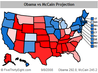 [1]
[1]…but with each state re-sized to visually represent its electoral college weight.
Naturally, this would distort the shape of the U.S. as a whole, at least if one wanted to keep borders touching as they do now. But could it be done? And done so that the country is still basically recognizeable?
Getting the areas right could be tricky, since these aren’t rectangles… One would have to be careful to avoid the sorts of accidental data distortion [2] sins Edward Tufte warns of, and which, in a sense, undistorted electoral maps like the one above are inherently guilty of. On the other hand, it doesn’t have to be precise, just close enough for government work (as the saying goes). Any tool that turns the black lines into grabbable, moveable boundaries, and counts the pixels inside to approximate the area of each state, would be fine. Of course, as you’re moving one state’s boundary, that of its neighboring state is changing too, so the interactions get complicated, hmm.
I have no idea if such tools exist anyway, though. Dear lazyweb… [3]